Geolocate

Itabuna topographic map

Click on the map to display elevation.

About this map

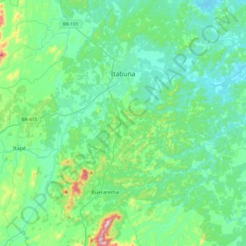
Name: Itabuna topographic map, elevation, terrain.

Location: Itabuna, Região Geográfica Imediata de Ilhéus – Itabuna, Região Geográfica Intermediária de Ilhéus-Itabuna, Bahia, Northeast Region, Brazil (-15.03300 -39.48400 -14.69100 -39.22100)

Average elevation: 374 ft

Minimum elevation: 7 ft

Maximum elevation: 2,142 ft

Other topographic maps

Click on a map to view its topography, its elevation and its terrain.

Terra Verde

Brazil > Bahia > Itamaraju

Average elevation: 489 ft

Marau

Brazil > Bahia > Itapebi

Average elevation: 295 ft

Arrecifes

Brazil > Bahia

Average elevation: 1,936 ft

Chicão

Brazil > Bahia > Seabra

Average elevation: 3,868 ft

Serra do Salitre

Brazil > Bahia > Ibipeba

Average elevation: 2,254 ft

Cocos

Brazil > Bahia > Cocos > Cocos

Average elevation: 1,946 ft

Porto Seguro

Brazil > Bahia > Porto Seguro

Average elevation: 89 ft

Savana

Brazil > Bahia > Ibiquera

Average elevation: 1,946 ft

Saquinho

Brazil > Bahia > Seabra

Average elevation: 2,864 ft

Gear up for your next adventure:

🌄Hiking Binoculars - Compact binoculars for scenic views and trail spotting
🛰️Handheld GPS Units - Professional satellite navigators for precise backcountry mapping
🏕️Family Camping Gear - Essentials for group camping trips
📡Handheld GPS Device - Reliable handheld GPS for outdoor navigation
📱Heavy-Duty Phone Cases - Drop-proof and waterproof protection for outdoor navigation

As an Amazon Associate, this site earns from qualifying purchases at no extra cost to you.