
Thank you for supporting this site ❤️
Make a donation
Make a donation
Gear up for your next adventure:
As an Amazon Associate, this site earns from qualifying purchases at no extra cost to you.
Coatepeque topographic map
Click on the map to display elevation.
Thank you for supporting this site ❤️
Make a donation
Make a donation
Gear up for your next adventure:
As an Amazon Associate, this site earns from qualifying purchases at no extra cost to you.
About this map
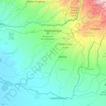
Name: Coatepeque topographic map, elevation, terrain.
Location: Coatepeque, Quetzaltenango, 09020, Guatemala (14.53276 -92.13850 14.73027 -91.80331)
Average elevation: 1,093 ft
Minimum elevation: 10 ft
Maximum elevation: 5,676 ft
Thank you for supporting this site ❤️
Make a donation
Make a donation
Gear up for your next adventure:
As an Amazon Associate, this site earns from qualifying purchases at no extra cost to you.