
Thank you for supporting this site ❤️
Make a donation
Make a donation
Gear up for your next adventure:
As an Amazon Associate, this site earns from qualifying purchases at no extra cost to you.
Archidona topographic map
Click on the map to display elevation.
Thank you for supporting this site ❤️
Make a donation
Make a donation
Gear up for your next adventure:
As an Amazon Associate, this site earns from qualifying purchases at no extra cost to you.
About this map
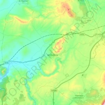
Name: Archidona topographic map, elevation, terrain.
Location: Archidona, Nororma, Malaga, Andalusia, Spain (37.02494 -4.49327 37.17271 -4.28283)
Average elevation: 2,313 ft
Minimum elevation: 1,496 ft
Maximum elevation: 4,311 ft
Thank you for supporting this site ❤️
Make a donation
Make a donation
Gear up for your next adventure:
As an Amazon Associate, this site earns from qualifying purchases at no extra cost to you.
Other topographic maps
Click on a map to view its topography, its elevation and its terrain.
Villanueva de Algaidas
Spain > Andalusia > Nororma > Villanueva de Algaidas
Average elevation: 1,814 ft