
Grenzach topographic map
Interactive map
Click on the map to display elevation.
About this map
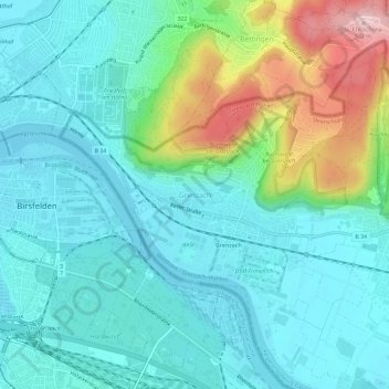
Name: Grenzach topographic map, elevation, terrain.
Average elevation: 1,027 ft
Minimum elevation: 823 ft
Maximum elevation: 1,706 ft
Other topographic maps
Click on a map to view its topography, its elevation and its terrain.
Marzell
Duitsland > Baden-Württemberg > Landkreis Lörrach > Malsburg-Marzell
Marzell, Malsburg-Marzell, Verwaltungsgemeinschaft Kandern, Landkreis Lörrach, Baden-Württemberg, 79429, Duitsland
Average elevation: 2,861 ft
Todtnau
Duitsland > Baden-Württemberg > Landkreis Lörrach
Todtnau, Landkreis Lörrach, Baden-Württemberg, 79674, Duitsland
Average elevation: 3,238 ft