
Bhairamgarh Tahsil topographic map
Interactive map
Click on the map to display elevation.
About this map
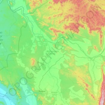
Name: Bhairamgarh Tahsil topographic map, elevation, terrain.
Location: Bhairamgarh Tahsil, Bijapur District, Chhattisgarh, India (18.72952 80.52472 19.34636 81.23068)
Average elevation: 1,266 ft
Minimum elevation: 387 ft
Maximum elevation: 4,032 ft
Other topographic maps
Click on a map to view its topography, its elevation and its terrain.
Indravati National Park
India > Chhattisgarh > Bijapur District
Indravati National Park, Bhopalpattnam, Bijapur District, Chhattisgarh, India
Average elevation: 830 ft