
La Huardière topographic map
Interactive map
Click on the map to display elevation.
About this map
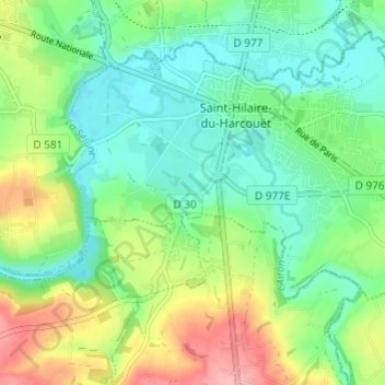
Name: La Huardière topographic map, elevation, terrain.
Average elevation: 312 ft
Minimum elevation: 187 ft
Maximum elevation: 558 ft
Other topographic maps
Click on a map to view its topography, its elevation and its terrain.
Saint-Hilaire-du-Harcouët
France > Normandie > Manche > Saint-Hilaire-du-Harcouët
Saint-Hilaire-du-Harcouët, Avranches, Manche, Normandie, France métropolitaine, 50600, France
Average elevation: 302 ft
La Petite Mazure
France > Normandie > Manche > Saint-Hilaire-du-Harcouët
La Petite Mazure, Saint-Hilaire-du-Harcouët, Avranches, Manche, Normandie, France métropolitaine, 50600, France
Average elevation: 295 ft
Saint-Martin-de-Landelles
France > Normandie > Manche > Saint-Hilaire-du-Harcouët
Saint-Martin-de-Landelles, Saint-Hilaire-du-Harcouët, Avranches, Manche, Normandie, France métropolitaine, 50730, France
Average elevation: 423 ft