
Make a donation
Gear up for your next adventure:
As an Amazon Associate, this site earns from qualifying purchases at no extra cost to you.
Rzeszów topographic map
Click on the map to display elevation.
Make a donation
Gear up for your next adventure:
As an Amazon Associate, this site earns from qualifying purchases at no extra cost to you.
About this map
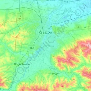
Name: Rzeszów topographic map, elevation, terrain.
Location: Rzeszów, Subcarpathian Voivodeship, Poland (49.93258 21.85868 50.09419 22.09415)
Average elevation: 781 ft
Minimum elevation: 623 ft
Maximum elevation: 1,309 ft
Make a donation
Gear up for your next adventure:
As an Amazon Associate, this site earns from qualifying purchases at no extra cost to you.
Other topographic maps
Click on a map to view its topography, its elevation and its terrain.
Bieszczady
Poland > Subcarpathian Voivodeship > Bieszczady County > Zatwarnica
Average elevation: 3,045 ft
Górny Koniec
Poland > Subcarpathian Voivodeship > Dębica County > Stara Jastrząbka
Average elevation: 787 ft
Wielkopolska
Poland > Subcarpathian Voivodeship > Rzeszów County > Chmielnik
Average elevation: 997 ft
Make a donation
Gear up for your next adventure:
As an Amazon Associate, this site earns from qualifying purchases at no extra cost to you.
Grzybowa Góra
Poland > Subcarpathian Voivodeship > Stalowa Wola County > Jastkowice
Average elevation: 571 ft
Wasile
Poland > Subcarpathian Voivodeship > Nisko County > Majdan Golczański
Average elevation: 630 ft
Błonie Rzeźnicze
Poland > Subcarpathian Voivodeship > Przeworsk County > Przeworsk
Average elevation: 650 ft
Make a donation
Gear up for your next adventure:
As an Amazon Associate, this site earns from qualifying purchases at no extra cost to you.
Haliga
Poland > Subcarpathian Voivodeship > Przemyśl County > Przedmieście Dubieckie
Average elevation: 889 ft
Mokłuczka
Poland > Subcarpathian Voivodeship > Rzeszów County > Błażowa Dolna
Average elevation: 1,050 ft
Make a donation
Gear up for your next adventure:
As an Amazon Associate, this site earns from qualifying purchases at no extra cost to you.
Stalowa Wola
Poland > Subcarpathian Voivodeship > Stalowa Wola County > Stalowa Wola
Average elevation: 518 ft
Make a donation
Gear up for your next adventure:
As an Amazon Associate, this site earns from qualifying purchases at no extra cost to you.