
Make a donation
Gear up for your next adventure:
As an Amazon Associate, this site earns from qualifying purchases at no extra cost to you.
Ariano Irpino topographic map
Click on the map to display elevation.
Make a donation
Gear up for your next adventure:
As an Amazon Associate, this site earns from qualifying purchases at no extra cost to you.
Ariano Irpino
At an elevation of 788 metres (2,585 ft) above sea level, Ariano Irpino is centered between the Adriatic Sea and the Tyrrhenian Sea. It is 39 km east of Benevento, 51 km north-east of Avellino and 62 km south-west of Foggia.
Make a donation
Gear up for your next adventure:
As an Amazon Associate, this site earns from qualifying purchases at no extra cost to you.
About this map
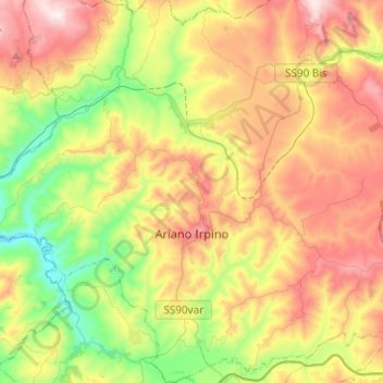
Name: Ariano Irpino topographic map, elevation, terrain.
Location: Ariano Irpino, Avellino, Campania, 83031, Italy (41.08086 14.98963 41.26482 15.22369)
Average elevation: 1,677 ft
Minimum elevation: 574 ft
Maximum elevation: 3,071 ft
Make a donation
Gear up for your next adventure:
As an Amazon Associate, this site earns from qualifying purchases at no extra cost to you.
Other topographic maps
Click on a map to view its topography, its elevation and its terrain.
Make a donation
Gear up for your next adventure:
As an Amazon Associate, this site earns from qualifying purchases at no extra cost to you.