Geolocate

Gruene topographic map

Click on the map to display elevation.

About this map

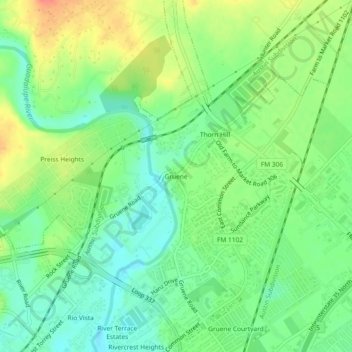
Name: Gruene topographic map, elevation, terrain.

Location: Gruene, New Braunfels, Comal County, Texas, 78135, United States (29.71854 -98.12427 29.75854 -98.08427)

Average elevation: 689 ft

Minimum elevation: 607 ft

Maximum elevation: 810 ft

Comal County trails, hiking, mountain biking, running and outdoor activities

Other topographic maps

Click on a map to view its topography, its elevation and its terrain.

Gear up for your next adventure:

📡Handheld GPS Device - Reliable handheld GPS for outdoor navigation
🧯Portable Fire Pit - Compact fire pit for camping spots
🛰️Handheld GPS Units - Professional satellite navigators for precise backcountry mapping
🪶Wildlife Field Guides - Learn animal tracking and species ID
🧦Merino Wool Socks - Moisture-wicking, blister-preventing socks for long treks

As an Amazon Associate, this site earns from qualifying purchases at no extra cost to you.