Make a donation
Gear up for your next adventure:
As an Amazon Associate, this site earns from qualifying purchases at no extra cost to you.
Peninsula topographic map
Click on the map to display elevation.
Make a donation
Gear up for your next adventure:
As an Amazon Associate, this site earns from qualifying purchases at no extra cost to you.
About this map
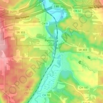
Name: Peninsula topographic map, elevation, terrain.
Location: Peninsula, Summit County, Ohio, United States (41.21916 -81.58454 41.25266 -81.51891)
Average elevation: 850 ft
Minimum elevation: 650 ft
Maximum elevation: 1,079 ft
Summit County trails, hiking, mountain biking, running and outdoor activities
Make a donation
Gear up for your next adventure:
As an Amazon Associate, this site earns from qualifying purchases at no extra cost to you.
Other topographic maps
Click on a map to view its topography, its elevation and its terrain.
Make a donation
Gear up for your next adventure:
As an Amazon Associate, this site earns from qualifying purchases at no extra cost to you.
Northampton Center
United States > Ohio > Summit County > Cuyahoga Falls > Northampton Center
Average elevation: 968 ft
Make a donation
Gear up for your next adventure:
As an Amazon Associate, this site earns from qualifying purchases at no extra cost to you.
Chittendens Corners
United States > Ohio > Summit County > Boston Heights > Chittendens Corners
Average elevation: 988 ft
East Center
United States > Ohio > Summit County > Richfield > East Center
Average elevation: 1,125 ft
Make a donation
Gear up for your next adventure:
As an Amazon Associate, this site earns from qualifying purchases at no extra cost to you.
