
Make a donation
Gear up for your next adventure:
As an Amazon Associate, this site earns from qualifying purchases at no extra cost to you.
South Farmingdale topographic map
Click on the map to display elevation.
Make a donation
Gear up for your next adventure:
As an Amazon Associate, this site earns from qualifying purchases at no extra cost to you.
South Farmingdale
South Farmingdale is located on a flat outwash plain, and as such, the hamlet's topography is largely flat. Additionally, South Farmingdale is split between the Massapequa Creek and Seaford Creek drainage areas, and is located within the larger Long Island Sound/Atlantic Ocean Watershed.
Make a donation
Gear up for your next adventure:
As an Amazon Associate, this site earns from qualifying purchases at no extra cost to you.
About this map
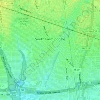
Name: South Farmingdale topographic map, elevation, terrain.
Average elevation: 62 ft
Minimum elevation: 33 ft
Maximum elevation: 89 ft
Nassau County trails, hiking, mountain biking, running and outdoor activities
Make a donation
Gear up for your next adventure:
As an Amazon Associate, this site earns from qualifying purchases at no extra cost to you.
Other topographic maps
Click on a map to view its topography, its elevation and its terrain.
Valley Stream
United States > New York > Nassau County > Valley Stream > Valley Stream
Average elevation: 30 ft
Make a donation
Gear up for your next adventure:
As an Amazon Associate, this site earns from qualifying purchases at no extra cost to you.