
Thank you for supporting this site ❤️
Make a donation
Make a donation
Gear up for your next adventure:
As an Amazon Associate, this site earns from qualifying purchases at no extra cost to you.
Tequexquináhuac topographic map
Click on the map to display elevation.
Thank you for supporting this site ❤️
Make a donation
Make a donation
Gear up for your next adventure:
As an Amazon Associate, this site earns from qualifying purchases at no extra cost to you.
About this map
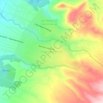
Name: Tequexquináhuac topographic map, elevation, terrain.
Location: Tequexquináhuac, Texcoco, State of Mexico, 56253, Mexico (19.45941 -98.84271 19.49941 -98.80271)
Average elevation: 8,068 ft
Minimum elevation: 7,635 ft
Maximum elevation: 8,622 ft
Thank you for supporting this site ❤️
Make a donation
Make a donation
Gear up for your next adventure:
As an Amazon Associate, this site earns from qualifying purchases at no extra cost to you.