

Feldberg topographic map
Click on the map to display elevation.
Feldberg
Feldberg is a municipality in the district of Breisgau-Hochschwarzwald in Baden-Württemberg in southern Germany. It is located near the Feldberg, the highest summit in Baden-Württemberg. It comprises the settlements of Altglashütten, Neuglashütten, Falkau, Bärental, and Feldberg. At an elevation of 1,277 m, the last is considered the highest village in Germany.
About this map
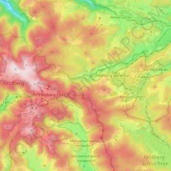
Name: Feldberg topographic map, elevation, terrain.
Average elevation: 3,514 ft
Minimum elevation: 1,998 ft
Maximum elevation: 4,908 ft
Other topographic maps
Click on a map to view its topography, its elevation and its terrain.
Oberried
Germany > Baden-Württemberg > Landkreis Breisgau-Hochschwarzwald
The Schauinsland (literally "look-into-the-country"; near Freiburg im Breisgau, Germany) is a mountain in the Black Forest with an elevation of 1,284 m (4,213 ft) above sea level. It is a popular destination for day trips. Due to the high amount of silver mining, it was previously known as "Erzkasten"…
Average elevation: 3,504 ft