Geolocate

Coltishall topographic map

Click on the map to display elevation.

About this map

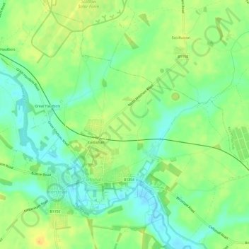
Name: Coltishall topographic map, elevation, terrain.

Location: Coltishall, Broadland, Norfolk, England, United Kingdom (52.71940 1.33753 52.75324 1.39731)

Average elevation: 43 ft

Minimum elevation: -3 ft

Maximum elevation: 79 ft

Other topographic maps

Click on a map to view its topography, its elevation and its terrain.

Thorpe End

United Kingdom > England > Norfolk > Broadland

Average elevation: 102 ft

Strumpshaw Hill

United Kingdom > England > Norfolk > Broadland

Average elevation: 62 ft

New Rackheath

United Kingdom > England > Norfolk > Broadland

Average elevation: 92 ft

Gear up for your next adventure:

🩳Quick‑Dry Hiking Shorts - Comfortable and quick‑dry shorts for summer hiking
🛶Inflatable Kayak - Portable kayak for rivers, lakes, and expeditions
🎒Trekking Poles - Sturdy poles for balance and stability on rough terrain
🧭GPS Watch Accessories - Bands and chargers for GPS watches
🧥Men's Rain Shells - Premium waterproof and breathable jackets for mountain weather

As an Amazon Associate, this site earns from qualifying purchases at no extra cost to you.