
Make a donation
Gear up for your next adventure:
As an Amazon Associate, this site earns from qualifying purchases at no extra cost to you.
Hees topographic map
Click on the map to display elevation.
Make a donation
Gear up for your next adventure:
As an Amazon Associate, this site earns from qualifying purchases at no extra cost to you.
Hees
Hees ligt in droog-Haspengouw op een hoogte van 74 tot 96 meter. De vruchtbare lössgrond wordt gebruikt voor de landbouw. Ten zuiden van Hees loopt de Wijerkensbeek in oostelijke richting, om in het Albertkanaal uit te monden.
Make a donation
Gear up for your next adventure:
As an Amazon Associate, this site earns from qualifying purchases at no extra cost to you.
About this map
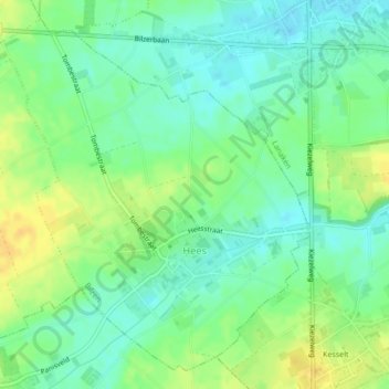
Name: Hees topographic map, elevation, terrain.
Location: Hees, Bilzen, Tongeren, Limburg, België (50.83775 5.58510 50.86213 5.62501)
Average elevation: 272 ft
Minimum elevation: 233 ft
Maximum elevation: 322 ft
Make a donation
Gear up for your next adventure:
As an Amazon Associate, this site earns from qualifying purchases at no extra cost to you.