
Stotel topographic map
Interactive map
Click on the map to display elevation.
About this map
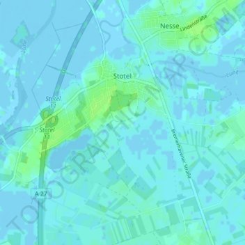
Name: Stotel topographic map, elevation, terrain.
Location: Stotel, Loxstedt, Landkreis Cuxhaven, Niedersachsen, Deutschland (53.42047 8.57007 53.46130 8.63609)
Average elevation: 7 ft
Minimum elevation: -10 ft
Maximum elevation: 33 ft
Other topographic maps
Click on a map to view its topography, its elevation and its terrain.
Hohewurth
Deutschland > Niedersachsen > Landkreis Cuxhaven > Loxstedt
Hohewurth, Loxstedt, Landkreis Cuxhaven, Niedersachsen, 27612, Deutschland
Average elevation: 7 ft
Bexhövede
Deutschland > Niedersachsen > Landkreis Cuxhaven > Loxstedt
Bexhövede, Loxstedt, Landkreis Cuxhaven, Niedersachsen, Deutschland
Average elevation: 20 ft
Donnern
Deutschland > Niedersachsen > Landkreis Cuxhaven > Loxstedt
Donnern, Loxstedt, Landkreis Cuxhaven, Niedersachsen, Deutschland
Average elevation: 26 ft