
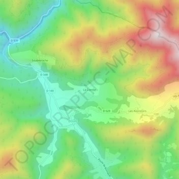
La Combe topographic map
Interactive map
Click on the map to display elevation.
About this map
Name: La Combe topographic map, elevation, terrain.
Average elevation: 3,301 ft
Minimum elevation: 2,169 ft
Maximum elevation: 4,948 ft
Other topographic maps
Click on a map to view its topography, its elevation and its terrain.
Soubreroche
France > Auvergne-Rhône-Alpes > Drôme > Boulc
Soubreroche, Boulc, Die, Drôme, Auvergne-Rhône-Alpes, France métropolitaine, 26410, France
Average elevation: 3,143 ft
Souvestrières
France > Auvergne-Rhône-Alpes > Drôme > Boulc
Souvestrières, Boulc, Die, Drôme, Auvergne-Rhône-Alpes, France métropolitaine, 26410, France
Average elevation: 4,124 ft
Les Tatins
France > Auvergne-Rhône-Alpes > Drôme > Boulc
Les Tatins, Boulc, Die, Drôme, Auvergne-Rhône-Alpes, France métropolitaine, 26410, France
Average elevation: 3,793 ft