
Make a donation
Gear up for your next adventure:
As an Amazon Associate, this site earns from qualifying purchases at no extra cost to you.
Аскиз topographic map
Click on the map to display elevation.
Make a donation
Gear up for your next adventure:
As an Amazon Associate, this site earns from qualifying purchases at no extra cost to you.
About this map
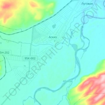
Name: Аскиз topographic map, elevation, terrain.
Average elevation: 1,204 ft
Minimum elevation: 1,096 ft
Maximum elevation: 1,768 ft
Make a donation
Gear up for your next adventure:
As an Amazon Associate, this site earns from qualifying purchases at no extra cost to you.
Other topographic maps
Click on a map to view its topography, its elevation and its terrain.
Нижняя Тёя
Россия > Республика Хакасия > Аскизский район
Расстояние до ближайшей железнодорожной станции Усть-Есь — 16 км. Нижняя Тёя расположена на правом берегу реки Тёя, на высоте около 435 м над уровнем моря.
Average elevation: 1,526 ft
Make a donation
Gear up for your next adventure:
As an Amazon Associate, this site earns from qualifying purchases at no extra cost to you.
Карлыган
Россия > Республика Хакасия > Аскизский район
Карлыган (хак. Харлыган «Заснеженный») — гора в верховьях рек Томь и Аскиз на границе Аскизского и Усть-Абаканского районов в северной части Абаканского хребта (53° 35' с.…
Average elevation: 4,948 ft
Make a donation
Gear up for your next adventure:
As an Amazon Associate, this site earns from qualifying purchases at no extra cost to you.
Make a donation
Gear up for your next adventure:
As an Amazon Associate, this site earns from qualifying purchases at no extra cost to you.