
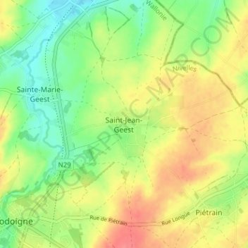
Saint-Jean-Geest topographic map
Interactive map
Click on the map to display elevation.
About this map
Name: Saint-Jean-Geest topographic map, elevation, terrain.
Average elevation: 269 ft
Minimum elevation: 174 ft
Maximum elevation: 374 ft
Other topographic maps
Click on a map to view its topography, its elevation and its terrain.
Piétrain
Belgique > Brabant wallon > Nivelles > Jodoigne
Piétrain, Jodoigne, Nivelles, Brabant wallon, Wallonie, Belgique
Average elevation: 295 ft
Arbre de la liberté
Belgique > Brabant wallon > Nivelles > Jodoigne
Arbre de la liberté, Grand'Place, Les Rendanges, Jodoigne, Nivelles, Brabant wallon, Wallonie, 1370, Belgique
Average elevation: 279 ft
Gobertange
Belgique > Brabant wallon > Nivelles > Jodoigne
Gobertange, Jodoigne, Nivelles, Brabant wallon, Wallonie, 1370, Belgique
Average elevation: 322 ft
Sainte-Marie-Geest
Belgique > Brabant wallon > Nivelles > Jodoigne > Sainte-Marie-Geest
Sainte-Marie-Geest, Jodoigne, Nivelles, Brabant wallon, Wallonie, 1370, Belgique
Average elevation: 269 ft