
Make a donation
Gear up for your next adventure:
As an Amazon Associate, this site earns from qualifying purchases at no extra cost to you.
Tinyarumi topographic map
Click on the map to display elevation.
Make a donation
Gear up for your next adventure:
As an Amazon Associate, this site earns from qualifying purchases at no extra cost to you.
About this map
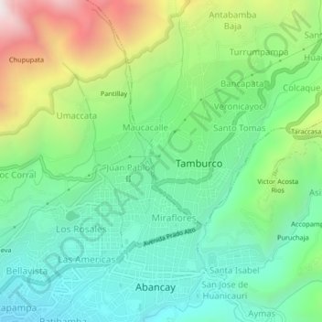
Name: Tinyarumi topographic map, elevation, terrain.
Location: Tinyarumi, Tamburco, Abancay, Apurímac, Perú (-13.64172 -72.89816 -13.60172 -72.85816)
Average elevation: 8,786 ft
Minimum elevation: 7,349 ft
Maximum elevation: 11,854 ft
Make a donation
Gear up for your next adventure:
As an Amazon Associate, this site earns from qualifying purchases at no extra cost to you.
Other topographic maps
Click on a map to view its topography, its elevation and its terrain.
Santuario Nacional de Ampay
La flora está caracterizada por intimpa (Podocarpus glomeratus) que crece por manchales formando bosques en las laderas. La presencia de vegetación a grandes altitudes da lugar a escenarios de gran belleza, que contrastan con las nieves perpetuas de las cumbres y con la aridez de los cerros circundantes.…
Average elevation: 12,336 ft