Geolocate

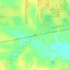
Caledonia topographic map

Click on the map to display elevation.

About this map

Name: Caledonia topographic map, elevation, terrain.

Location: Caledonia, Lowndes County, Mississippi, 39704, United States (33.66697 -88.34428 33.69711 -88.30520)

Average elevation: 315 ft

Minimum elevation: 230 ft

Maximum elevation: 367 ft

Lowndes County trails, hiking, mountain biking, running and outdoor activities

Other topographic maps

Click on a map to view its topography, its elevation and its terrain.

Billups

United States > Mississippi > Lowndes County

Average elevation: 236 ft

Gear up for your next adventure:

🔭Stargazing Telescopes - Perfect for camping in low-light pollution areas shown on maps
🌲Outdoor Survival Books - Best books on survival skills
🪓Survival Multi‑Tool - Versatile tool for camp and trail tasks
🧥Men's Rain Shells - Premium waterproof and breathable jackets for mountain weather
🎒Trekking Poles - Sturdy poles for balance and stability on rough terrain

As an Amazon Associate, this site earns from qualifying purchases at no extra cost to you.