
Kınık topographic map
Interactive map
Click on the map to display elevation.
About this map
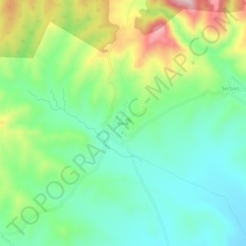
Name: Kınık topographic map, elevation, terrain.
Location: Kınık, Çorum Merkez, Çorum, Black Sea Region, Turkey (40.44404 34.72819 40.48404 34.76819)
Average elevation: 3,058 ft
Minimum elevation: 2,687 ft
Maximum elevation: 3,812 ft
Other topographic maps
Click on a map to view its topography, its elevation and its terrain.
Kavacık
Turkey > Çorum Merkez > Kavacık
Kavacık, Çorum Merkez, Çorum, Black Sea Region, Turkey
Average elevation: 3,652 ft
Elmalı
Turkey > Çorum Merkez > Elmalı
Elmalı, Çorum Merkez, Çorum, Black Sea Region, Turkey
Average elevation: 3,691 ft
Değirmendere
Değirmendere, Çorum Merkez, Çorum, Black Sea Region, Turkey
Average elevation: 4,144 ft