
Eddleston topographic map
Interactive map
Click on the map to display elevation.
About this map
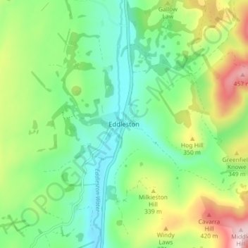
Name: Eddleston topographic map, elevation, terrain.
Average elevation: 925 ft
Minimum elevation: 597 ft
Maximum elevation: 1,578 ft
Other topographic maps
Click on a map to view its topography, its elevation and its terrain.
Viewfield
United Kingdom > Scotland > Scottish Borders
Viewfield, Scottish Borders, Scotland, TD10 6UW, United Kingdom
Average elevation: 446 ft
Hawick
United Kingdom > Scotland > Scottish Borders
Hawick, Scottish Borders, Scotland, TD9 9EG, United Kingdom
Average elevation: 653 ft
Willie's Law
United Kingdom > Scotland > Scottish Borders
Willie's Law, Scottish Borders, Scotland, United Kingdom
Average elevation: 1,549 ft
Galashiels
United Kingdom > Scotland > Scottish Borders
Galashiels, Scottish Borders, Scotland, United Kingdom
Average elevation: 725 ft
Cavers
United Kingdom > Scotland > Scottish Borders > Cavers
Cavers, Scottish Borders, Scotland, TD9 8LJ, United Kingdom
Average elevation: 515 ft