
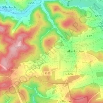
Altenkirchen topographic map
Interactive map
Click on the map to display elevation.
About this map
Name: Altenkirchen topographic map, elevation, terrain.
Location: Altenkirchen, Hohenahr, Lahn-Dill-Kreis, Hessen, Deutschland (50.65927 8.41442 50.69987 8.48246)
Average elevation: 1,063 ft
Minimum elevation: 797 ft
Maximum elevation: 1,332 ft
Other topographic maps
Click on a map to view its topography, its elevation and its terrain.
Erda
Deutschland > Hessen > Lahn-Dill-Kreis > Hohenahr
Erda, Hohenahr, Lahn-Dill-Kreis, Hessen, 35644, Deutschland
Average elevation: 1,050 ft
Altenberg
Deutschland > Hessen > Lahn-Dill-Kreis > Hohenahr
Altenberg, Hohenahr, Lahn-Dill-Kreis, Hessen, 35585, Deutschland
Average elevation: 1,201 ft
Hohensolms
Deutschland > Hessen > Lahn-Dill-Kreis > Hohenahr
Hohensolms, Hohenahr, Lahn-Dill-Kreis, Hessen, Deutschland
Average elevation: 1,161 ft