Geolocate

Larkspur topographic map

Click on the map to display elevation.

About this map

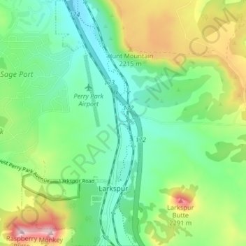
Name: Larkspur topographic map, elevation, terrain.

Location: Larkspur, Douglas County, Colorado, United States (39.21697 -104.90889 39.26753 -104.87743)

Average elevation: 6,896 ft

Minimum elevation: 6,529 ft

Maximum elevation: 7,674 ft

Douglas County trails, hiking, mountain biking, running and outdoor activities

Other topographic maps

Click on a map to view its topography, its elevation and its terrain.

Carriage Club

United States > Colorado > Douglas County > Lone Tree

Average elevation: 5,991 ft

Kistler Park

United States > Colorado > Douglas County

Average elevation: 5,774 ft

Bell Rock

United States > Colorado > Douglas County

Average elevation: 7,920 ft

Orsa

United States > Colorado > Douglas County

Average elevation: 6,056 ft

Moonridge

United States > Colorado > Douglas County

Average elevation: 7,457 ft

Bayou Hills

United States > Colorado > Douglas County > Bayou Hills

Average elevation: 6,375 ft

Heritage Estates

United States > Colorado > Douglas County > Lone Tree

Average elevation: 6,004 ft

Gear up for your next adventure:

🧺Microfiber Travel Towels - Compact and fast-drying towels for trail use
🎒Hydration Pack - Hands‑free water reservoir for long hikes
🪓Survival Multi‑Tool - Versatile tool for camp and trail tasks
Solar GPS Watches - Advanced multisport watches with built-in topographic maps
🧤Tactile Hiking Gloves - Keep hands warm while operating GPS and smartphone screens

As an Amazon Associate, this site earns from qualifying purchases at no extra cost to you.