
Bridal Veil Falls topographic map
Interactive map
Click on the map to display elevation.
About this map
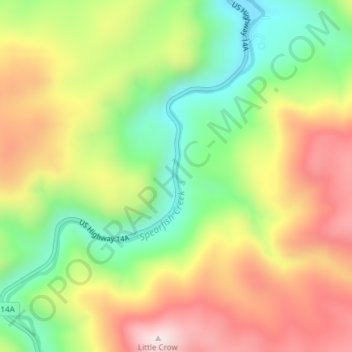
Name: Bridal Veil Falls topographic map, elevation, terrain.
Average elevation: 4,928 ft
Minimum elevation: 4,085 ft
Maximum elevation: 5,863 ft
Other topographic maps
Click on a map to view its topography, its elevation and its terrain.
Spearfish
United States > South Dakota > Lawrence County
Spearfish, Lawrence County, South Dakota, United States
Average elevation: 3,842 ft
Savoy
United States > South Dakota > Lawrence County
Savoy, Lawrence County, South Dakota, United States
Average elevation: 5,463 ft
Deadwood
United States > South Dakota > Lawrence County
Deadwood, Lawrence County, South Dakota, 57732, United States
Average elevation: 4,957 ft
Terry Peak
United States > South Dakota > Lawrence County
Terry Peak, Lawrence County, South Dakota, United States
Average elevation: 6,365 ft
Cheyenne Crossing
United States > South Dakota > Lawrence County
Cheyenne Crossing, Lawrence County, South Dakota, United States
Average elevation: 5,853 ft
Spearfish
United States > South Dakota > Lawrence County > Spearfish
Spearfish, Lawrence County, South Dakota, 57783, United States
Average elevation: 4,236 ft
Lead
United States > South Dakota > Lawrence County
Lead, Lawrence County, South Dakota, United States
Average elevation: 5,266 ft