
Grant Township topographic map
Interactive map
Click on the map to display elevation.
About this map
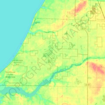
Name: Grant Township topographic map, elevation, terrain.
Location: Grant Township, Mason County, Michigan, United States (44.07927 -86.49017 44.17876 -86.27934)
Average elevation: 650 ft
Minimum elevation: 564 ft
Maximum elevation: 781 ft
Other topographic maps
Click on a map to view its topography, its elevation and its terrain.
Custer
United States > Michigan > Mason County
Custer, Custer Township, Mason County, Michigan, United States
Average elevation: 666 ft
Hamlin Lake
United States > Michigan > Mason County
Hamlin Lake, Hamlin Township, Mason County, Michigan, United States
Average elevation: 620 ft
Sugar Grove
United States > Michigan > Mason County
Sugar Grove, Sherman Township, Mason County, Michigan, United States
Average elevation: 676 ft
Branch Township
United States > Michigan > Mason County
Branch Township, Mason County, Michigan, 49458, United States
Average elevation: 709 ft
Free Soil
United States > Michigan > Mason County > Free Soil
Free Soil, Free Soil Township, Mason County, Michigan, United States
Average elevation: 679 ft
Ludington
United States > Michigan > Mason County
Ludington, Mason County, Michigan, United States
Average elevation: 604 ft
Pere Marquette Charter Township
United States > Michigan > Mason County
Pere Marquette Charter Township, Mason County, Michigan, 49431, United States
Average elevation: 640 ft