
Schœlcher topographic map
Interactive map
Click on the map to display elevation.
About this map
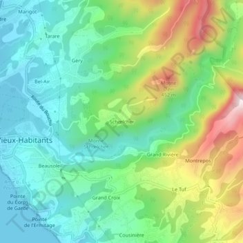
Name: Schœlcher topographic map, elevation, terrain.
Average elevation: 574 ft
Minimum elevation: 0 ft
Maximum elevation: 1,831 ft
Other topographic maps
Click on a map to view its topography, its elevation and its terrain.
Marigot
France > Guadeloupe > Vieux-Habitants
Marigot, Vieux-Habitants, Basse-Terre, Guadeloupe, 97119, France
Average elevation: 285 ft
Anse du Val de l'Orge
France > Guadeloupe > Vieux-Habitants
Anse du Val de l'Orge, Chemin du Front de Mer, Habitation Darius, Vieux-Habitants, Basse-Terre, Guadeloupe, 97119, France
Average elevation: 161 ft