
Thank you for supporting this site ❤️
Make a donation
Make a donation
Gear up for your next adventure:
As an Amazon Associate, this site earns from qualifying purchases at no extra cost to you.
Et-taous ⵟⴰⵡⵙ الطاوس topographic map
Click on the map to display elevation.
Thank you for supporting this site ❤️
Make a donation
Make a donation
Gear up for your next adventure:
As an Amazon Associate, this site earns from qualifying purchases at no extra cost to you.
About this map
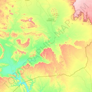
Name: Et-taous ⵟⴰⵡⵙ الطاوس topographic map, elevation, terrain.
Average elevation: 2,500 ft
Minimum elevation: 1,949 ft
Maximum elevation: 3,497 ft
Thank you for supporting this site ❤️
Make a donation
Make a donation
Gear up for your next adventure:
As an Amazon Associate, this site earns from qualifying purchases at no extra cost to you.
Other topographic maps
Click on a map to view its topography, its elevation and its terrain.
Ouzina
Morocco > Drâa-Tafilalet > Cercle d'Er-Rissani > Et-taous ⵟⴰⵡⵙ الطاوس
Average elevation: 2,182 ft