Geolocate

Reading topographic map

Click on the map to display elevation.

About this map

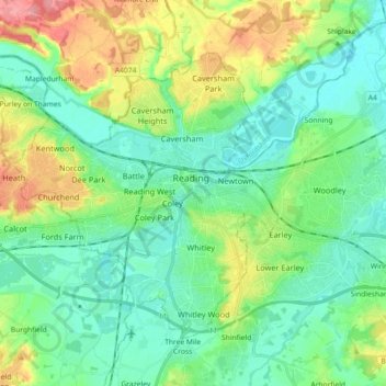
Name: Reading topographic map, elevation, terrain.

Location: Reading, Oxfordshire, England, United Kingdom (51.41237 -1.06102 51.49189 -0.88025)

Average elevation: 190 ft

Minimum elevation: 98 ft

Maximum elevation: 413 ft

Gear up for your next adventure:

🔪Outdoor Multitools - Essential survival tools for gear repair and field use
🥄Camping Utensil Set - Lightweight utensils for outdoor meals
🎒Gear Packing Cubes - Organize your backpack efficiently
👓Polarized Sunglasses - Outdoor sunglasses for glare reduction
🌲Outdoor Survival Books - Best books on survival skills

As an Amazon Associate, this site earns from qualifying purchases at no extra cost to you.