
Berekuso topographic map
Interactive map
Click on the map to display elevation.
About this map
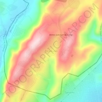
Name: Berekuso topographic map, elevation, terrain.
Location: Berekuso, Akuapim South District, Eastern Region, Ghana (5.73936 -0.24504 5.77936 -0.20504)
Average elevation: 738 ft
Minimum elevation: 259 ft
Maximum elevation: 1,250 ft
Other topographic maps
Click on a map to view its topography, its elevation and its terrain.
Kitase
Ghana > Eastern Region > Akuapim South District
Kitase, Akuapim South District, Eastern Region, Ghana
Average elevation: 974 ft