
San Vicente de Nimbra topographic map
Interactive map
Click on the map to display elevation.
About this map
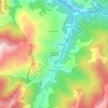
Name: San Vicente de Nimbra topographic map, elevation, terrain.
Location: San Vicente de Nimbra, Quirós, Asturias, 33116, España (43.11280 -5.99016 43.15280 -5.95016)
Average elevation: 2,822 ft
Minimum elevation: 1,532 ft
Maximum elevation: 4,501 ft
Other topographic maps
Click on a map to view its topography, its elevation and its terrain.
Villaorille
España > Asturias > Quirós > Villaorille
Villaorille, Quirós, Asturias, 33118, España
Average elevation: 2,077 ft
Parque Natural de Las Ubiñas-La Mesa
Parque Natural de Las Ubiñas-La Mesa, QU-3, Quirós, Asturias, 33116, España
Average elevation: 3,661 ft