
Brasstown topographic map
Interactive map
Click on the map to display elevation.
About this map
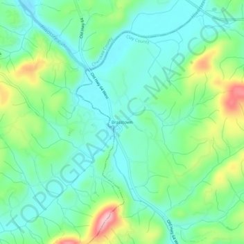
Name: Brasstown topographic map, elevation, terrain.
Location: Brasstown, Clay County, North Carolina, 28902, United States (35.01953 -83.97685 35.05953 -83.93685)
Average elevation: 1,719 ft
Minimum elevation: 1,558 ft
Maximum elevation: 2,119 ft
Other topographic maps
Click on a map to view its topography, its elevation and its terrain.
Hayesville
United States > North Carolina > Clay County
Hayesville, Clay County, North Carolina, United States
Average elevation: 1,880 ft
Shooting Creek
United States > North Carolina > Clay County
Shooting Creek, Clay County, North Carolina, United States
Average elevation: 2,293 ft
Hayesville
United States > North Carolina > Clay County > Town of Hayesville > Hayesville
Hayesville, Town of Hayesville, Clay County, North Carolina, 28904, United States
Average elevation: 1,972 ft
Beach Mountain
United States > North Carolina > Clay County
Beach Mountain, Clay County, North Carolina, 28909, United States
Average elevation: 2,028 ft