
Make a donation
Gear up for your next adventure:
As an Amazon Associate, this site earns from qualifying purchases at no extra cost to you.
Morella topographic map
Click on the map to display elevation.
Make a donation
Gear up for your next adventure:
As an Amazon Associate, this site earns from qualifying purchases at no extra cost to you.
Morella
Morella has an Oceanic climate (Köppen: Cfb) highly influenced by its altitude around 1,000 metres (3,300 ft) and its well inland location, with warm summers and cool winters (cold for Spanish standards) with frequent frosts and snow. Temperatures as low as −10 °C (14 °F) and heavy snowfalls can happen during harsh cold spells. The highest temperature ever recorded in Morella was 40 °C (104 °F) in 16 August 1925, while the coldest temperature recorded was −17 °C (1 °F) in 17 December 1933.
Make a donation
Gear up for your next adventure:
As an Amazon Associate, this site earns from qualifying purchases at no extra cost to you.
About this map
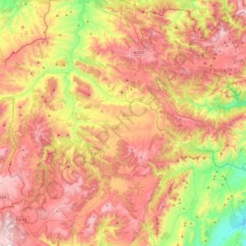
Name: Morella topographic map, elevation, terrain.
Average elevation: 3,114 ft
Minimum elevation: 1,329 ft
Maximum elevation: 4,705 ft
Make a donation
Gear up for your next adventure:
As an Amazon Associate, this site earns from qualifying purchases at no extra cost to you.
Other topographic maps
Click on a map to view its topography, its elevation and its terrain.
Isla Nueva
Spain > Valencian Community > el Baix Segura / La Vega Baja del Segura > Benferri
Average elevation: 305 ft