
San Miguel topographic map
Interactive map
Click on the map to display elevation.
About this map
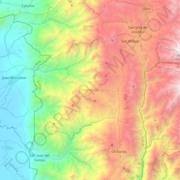
Name: San Miguel topographic map, elevation, terrain.
Location: San Miguel, Bolívar, 020301, Ecuador (-1.94047 -79.25567 -1.68466 -78.87270)
Average elevation: 5,449 ft
Minimum elevation: 39 ft
Maximum elevation: 13,527 ft
Other topographic maps
Click on a map to view its topography, its elevation and its terrain.
Santiago
Ecuador > Bolívar > San Miguel
Santiago, San Miguel, Bolívar, Ecuador
Average elevation: 9,360 ft
San Vicente
Ecuador > Bolívar > San Miguel
San Vicente, San Miguel, Bolívar, Ecuador
Average elevation: 8,625 ft
San Jose de las Palmas
Ecuador > Bolívar > San Miguel > San Pablo de Atenas
San Jose de las Palmas, San Pablo de Atenas, San Miguel, Bolívar, Ecuador
Average elevation: 8,855 ft
San Miguel
Ecuador > Bolívar > San Miguel
San Miguel, Bolívar, 020301, Ecuador
Average elevation: 8,445 ft