Geolocate

Logan topographic map

Click on the map to display elevation.

About this map

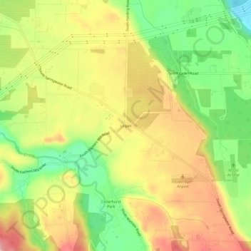
Name: Logan topographic map, elevation, terrain.

Location: Logan, Clackamas County, Oregon, United States (45.32345 -122.44287 45.36345 -122.40287)

Average elevation: 430 ft

Minimum elevation: 184 ft

Maximum elevation: 663 ft

Clackamas County trails, hiking, mountain biking, running and outdoor activities

Other topographic maps

Click on a map to view its topography, its elevation and its terrain.

Clackamas River

United States > Oregon > Clackamas County

Average elevation: 1,745 ft

Johnson City

United States > Oregon > Clackamas County

Average elevation: 164 ft

Wilsonville

United States > Oregon > Clackamas County

Wilsonville is located on the southern edge of the Portland metropolitan area sitting at an elevation of 154 feet (47 m) above sea level. Primarily in the southwestern part of Clackamas County, the northern section is in Washington County. It is located on the north side of the Willamette River around where…

Average elevation: 197 ft

Rivergrove

United States > Oregon > Clackamas County

Average elevation: 174 ft

Barlow

United States > Oregon > Clackamas County

Average elevation: 102 ft

Willamette

United States > Oregon > Clackamas County > West Linn

Average elevation: 344 ft

Oak Creek

United States > Oregon > Clackamas County > Lake Oswego

Average elevation: 404 ft

Cedar Island

United States > Oregon > Clackamas County > West Linn

Average elevation: 125 ft

Gear up for your next adventure:

🧭Outdoor Navigation Book - Learn advanced navigation skills
🧭GPS Watch Accessories - Bands and chargers for GPS watches
🥄Camping Utensil Set - Lightweight utensils for outdoor meals
🪶Survival Guide Book - Expert advice for emergency preparedness
Solar GPS Watches - Advanced multisport watches with built-in topographic maps

As an Amazon Associate, this site earns from qualifying purchases at no extra cost to you.