
Make a donation
Gear up for your next adventure:
As an Amazon Associate, this site earns from qualifying purchases at no extra cost to you.
Tamantirto topographic map
Click on the map to display elevation.
Make a donation
Gear up for your next adventure:
As an Amazon Associate, this site earns from qualifying purchases at no extra cost to you.
About this map
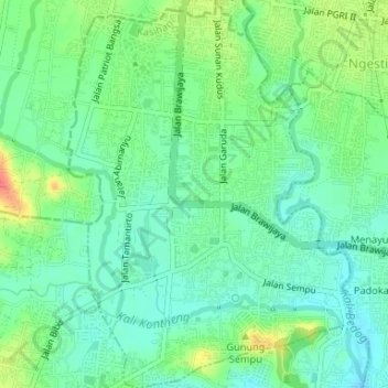
Name: Tamantirto topographic map, elevation, terrain.
Average elevation: 285 ft
Minimum elevation: 226 ft
Maximum elevation: 407 ft
Make a donation
Gear up for your next adventure:
As an Amazon Associate, this site earns from qualifying purchases at no extra cost to you.
Other topographic maps
Click on a map to view its topography, its elevation and its terrain.
Depok Beach
Indonesia > Special Region of Yogyakarta > Bantul Regency > Parangtritis
Average elevation: 10 ft
Sayangan
Indonesia > Special Region of Yogyakarta > Bantul Regency > Jagalan
Average elevation: 269 ft
Gerojogan Lepo
Indonesia > Special Region of Yogyakarta > Bantul Regency > Dlingo
Average elevation: 436 ft