
Isla Pan de Azúcar topographic map
Interactive map
Click on the map to display elevation.
About this map
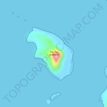
Name: Isla Pan de Azúcar topographic map, elevation, terrain.
Location: Isla Pan de Azúcar, Chañaral, Región de Atacama, Chile (-26.16380 -70.69488 -26.14893 -70.68010)
Average elevation: 16 ft
Minimum elevation: 0 ft
Maximum elevation: 643 ft
Other topographic maps
Click on a map to view its topography, its elevation and its terrain.
Parque Nacional Pan de Azúcar
Chile > Región de Atacama > Chañaral
Parque Nacional Pan de Azúcar, Chañaral - Pan de Azúcar, Barquito, Chañaral, Provincia de Chañaral, Región de Atacama, 1490000, Chile
Average elevation: 184 ft