
Make a donation
Gear up for your next adventure:
As an Amazon Associate, this site earns from qualifying purchases at no extra cost to you.
Tempel topographic map
Click on the map to display elevation.
Make a donation
Gear up for your next adventure:
As an Amazon Associate, this site earns from qualifying purchases at no extra cost to you.
About this map
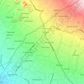
Name: Tempel topographic map, elevation, terrain.
Average elevation: 945 ft
Minimum elevation: 417 ft
Maximum elevation: 1,886 ft
Make a donation
Gear up for your next adventure:
As an Amazon Associate, this site earns from qualifying purchases at no extra cost to you.
Other topographic maps
Click on a map to view its topography, its elevation and its terrain.
Wisdom park
Indonesia > Special Region of Yogyakarta > Sleman Regency > Catur tunggal
Average elevation: 446 ft
taman sari
Indonesia > Special Region of Yogyakarta > Sleman Regency > Sinduharjo
Average elevation: 568 ft
Pakem Binangun
Indonesia > Special Region of Yogyakarta > Sleman Regency > Pakembinangun
Average elevation: 1,470 ft
Make a donation
Gear up for your next adventure:
As an Amazon Associate, this site earns from qualifying purchases at no extra cost to you.
SUNGAI OPAK
Indonesia > Special Region of Yogyakarta > Sleman Regency > Leses
Average elevation: 774 ft
Ngipiksari
Indonesia > Special Region of Yogyakarta > Sleman Regency > Hargobinangun > Kaliurang
Average elevation: 2,605 ft
Cangkringan
Indonesia > Special Region of Yogyakarta > Sleman Regency > Argomulyo
Average elevation: 1,486 ft
Kalasan
Indonesia > Special Region of Yogyakarta > Sleman Regency > Tirtomartani
Average elevation: 469 ft
Make a donation
Gear up for your next adventure:
As an Amazon Associate, this site earns from qualifying purchases at no extra cost to you.
Minggir
Indonesia > Special Region of Yogyakarta > Sleman Regency > Sendangagung
Average elevation: 466 ft
Margoagung
Indonesia > Special Region of Yogyakarta > Sleman Regency > Margoagung
Average elevation: 636 ft
Sungai Code
Indonesia > Special Region of Yogyakarta > Sleman Regency > Yogyakarta
Average elevation: 361 ft
Kemiri Kebo
Indonesia > Special Region of Yogyakarta > Sleman Regency > Girikerto
Average elevation: 2,339 ft
Make a donation
Gear up for your next adventure:
As an Amazon Associate, this site earns from qualifying purchases at no extra cost to you.
Margo Rejo
Indonesia > Special Region of Yogyakarta > Sleman Regency > Margorejo
Average elevation: 997 ft
Lumbung Rejo
Indonesia > Special Region of Yogyakarta > Sleman Regency > Lumbungrejo
Average elevation: 1,109 ft
Tempel
Indonesia > Special Region of Yogyakarta > Sleman Regency > Lumbungrejo
Average elevation: 1,060 ft
Tlogo Putri Kaliurang
Indonesia > Special Region of Yogyakarta > Sleman Regency > Hargobinangun > Kaliurang
Average elevation: 3,110 ft
Make a donation
Gear up for your next adventure:
As an Amazon Associate, this site earns from qualifying purchases at no extra cost to you.
Sumber Rejo
Indonesia > Special Region of Yogyakarta > Sleman Regency > Sumberrejo
Average elevation: 764 ft
Jogotirto
Indonesia > Special Region of Yogyakarta > Sleman Regency > Jogotirto
Average elevation: 315 ft
Kaliurang
Indonesia > Special Region of Yogyakarta > Sleman Regency > Hargobinangun
Average elevation: 2,815 ft
Embung Tambakboyo
Indonesia > Special Region of Yogyakarta > Sleman Regency > Condongcatur > Condong Catur
Average elevation: 538 ft
Make a donation
Gear up for your next adventure:
As an Amazon Associate, this site earns from qualifying purchases at no extra cost to you.
Bangun Kerto
Indonesia > Special Region of Yogyakarta > Sleman Regency > Bangunkerto
Average elevation: 1,243 ft