
Aïn Séfra topographic map
Interactive map
Click on the map to display elevation.
About this map
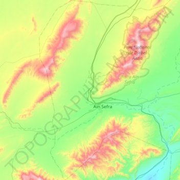
Name: Aïn Séfra topographic map, elevation, terrain.
Location: Aïn Séfra, daïra Ain Sefra, Naâma, 45200, Algérie (32.56876 -0.77096 33.02796 -0.38731)
Average elevation: 4,222 ft
Minimum elevation: 2,940 ft
Maximum elevation: 7,323 ft
Other topographic maps
Click on a map to view its topography, its elevation and its terrain.
Tiout
Algérie > Naâma > Daïra de Aïn Séfra
Tiout, Daïra de Aïn Séfra, Naâma, 45210, Algérie
Average elevation: 4,078 ft