
Soto de los Infantes topographic map
Interactive map
Click on the map to display elevation.
About this map
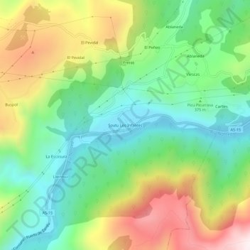
Name: Soto de los Infantes topographic map, elevation, terrain.
Location: Soto de los Infantes, Salas, Asturias, 33859, España (43.33990 -6.29088 43.37990 -6.25088)
Average elevation: 1,411 ft
Minimum elevation: 374 ft
Maximum elevation: 3,150 ft
Other topographic maps
Click on a map to view its topography, its elevation and its terrain.
La Piniella
España > Asturias > Salas > La Estrada
La Piniella, La Estrada, Salas, Asturias, 33867, España
Average elevation: 1,030 ft
San Martín
San Martín, Salas, Asturias, 33860, España
Average elevation: 1,115 ft