
De Rug topographic map
Interactive map
Click on the map to display elevation.
About this map
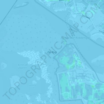
Name: De Rug topographic map, elevation, terrain.
Location: De Rug, Lauwersoog, Het Hogeland, Groningen, Nederland (53.38356 6.17887 53.40354 6.21248)
Average elevation: -7 ft
Minimum elevation: -20 ft
Maximum elevation: 10 ft
Other topographic maps
Click on a map to view its topography, its elevation and its terrain.
Lauwersoog
Nederland > Groningen > Het Hogeland > Lauwersoog
Lauwersoog, Het Hogeland, Groningen, Nederland
Average elevation: -3 ft
Lauwersmeer
Nederland > Groningen > Lauwersoog
Lauwersmeer, Lauwersoog, Het Hogeland, Groningen, Nederland
Average elevation: -3 ft