
Municipal Unit of Ano Liosia topographic map
Interactive map
Click on the map to display elevation.
About this map
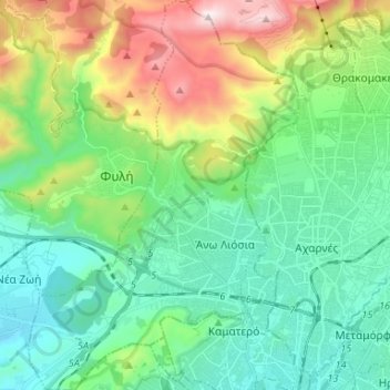
Name: Municipal Unit of Ano Liosia topographic map, elevation, terrain.
Average elevation: 1,168 ft
Minimum elevation: 164 ft
Maximum elevation: 3,816 ft
Other topographic maps
Click on a map to view its topography, its elevation and its terrain.
Vilia
Greece > Attica > Regional Unit of West Attica > Municipal Unit of Vilia
Vilia, Municipal Unit of Vilia, Municipality of Mandra-Eidyllia, Regional Unit of West Attica, Attica, 190 12, Greece
Average elevation: 1,982 ft
Aspropyrgos
Greece > Attica > Regional Unit of West Attica
Aspropyrgos, Municipality of Aspropyrgos, Regional Unit of West Attica, Attica, 193 00, Greece
Average elevation: 174 ft
Psatha
Greece > Attica > Regional Unit of West Attica > Municipal Unit of Vilia > Psatha
Psatha, Community of Vilia, Municipal Unit of Vilia, Municipality of Mandra-Eidyllia, Regional Unit of West Attica, Attica, 190 12, Greece
Average elevation: 259 ft
Eleusis
Greece > Attica > Regional Unit of West Attica > Municipal Unit of Elefsina
Eleusis, Municipal Unit of Elefsina, Municipality of Elefsina, Regional Unit of West Attica, Attica, 192 00, Greece
Average elevation: 98 ft