
Bas-Rhin topographic map
Interactive map
Click on the map to display elevation.
Bas-Rhin
Bas-Rhin (French pronunciation: [bɑ ʁɛ̃] ) is a département in Alsace which is a part of the Grand Est super-region of France. The name means 'Lower Rhine', referring to its lower altitude among the two French Rhine departments: it is downstream of the Haut-Rhin (Upper Rhine) department. Both belong to the European Upper Rhine region. It is, with the Haut-Rhin (Upper Rhine), one of the two departments of the traditional Alsace region which until 1871, also included the area now known as the Territoire de Belfort. The more populous and densely populated of the pair, it had 1,152,662 inhabitants in 2021. The prefecture is based in Strasbourg. The INSEE and Post Code is 67.
About this map
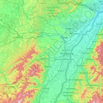
Name: Bas-Rhin topographic map, elevation, terrain.
Location: Bas-Rhin, Grand Est, Metropolitan France, France (48.12043 6.94063 49.07779 8.23285)
Average elevation: 1,033 ft
Minimum elevation: 341 ft
Maximum elevation: 4,180 ft
Other topographic maps
Click on a map to view its topography, its elevation and its terrain.
Col du Platzerwasel
France > Grand Est > Haut-Rhin > Mittlach
The Col du Platzerwasel (elevation 1,182 m (3,878 ft)) is a mountain pass situated in the Vosges Mountains in the Haut-Rhin department of France, between Sondernach and Le Markstein. It has been crossed occasionally during the Tour de France cycle race, including on Stage 10 of the 2014 race.
Average elevation: 3,360 ft
La Trace
France > Grand Est > Haute-Marne > Roches-Bettaincourt > Bettaincourt-sur-Rognon
Average elevation: 889 ft
Berges de la Birsig
France > Grand Est > Haut-Rhin > Leymen > Berges de la Birsig
Average elevation: 1,312 ft
Quartier des Aviateurs
France > Grand Est > Bas-Rhin > Sélestat > Quartier des Aviateurs
Average elevation: 574 ft