
Industriehaven Avelingen-Oost topographic map
Interactive map
Click on the map to display elevation.
About this map
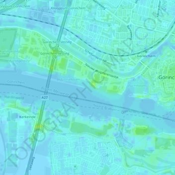
Name: Industriehaven Avelingen-Oost topographic map, elevation, terrain.
Average elevation: 7 ft
Minimum elevation: -10 ft
Maximum elevation: 36 ft
Other topographic maps
Click on a map to view its topography, its elevation and its terrain.
Gorinchem
Nederland > Zuid-Holland > Gorinchem
Gorinchem, Zuid-Holland, Nederland
Average elevation: 3 ft
Groote Haar
Nederland > Zuid-Holland > Gorinchem
Groote Haar, Gorinchem, Zuid-Holland, Nederland, 4205 NE, Nederland
Average elevation: 3 ft
Dalem
Nederland > Zuid-Holland > Gorinchem
Dalem, Gorinchem, Zuid-Holland, Nederland
Average elevation: 7 ft
Merwedekanaal
Nederland > Zuid-Holland > Gorinchem
Merwedekanaal, Gorinchem, Zuid-Holland, Nederland, 4241TB, Nederland
Average elevation: 3 ft