
Servota topographic map
Interactive map
Click on the map to display elevation.
About this map
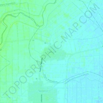
Name: Servota topographic map, elevation, terrain.
Average elevation: 312 ft
Minimum elevation: 299 ft
Maximum elevation: 328 ft
Other topographic maps
Click on a map to view its topography, its elevation and its terrain.
Meteora
Greece > Thessaly and Central Greece > Trikala Regional Unit > Kastraki
Meteora, Kastraki, Meteora Municipality, Trikala Regional Unit, Thessaly, Thessaly and Central Greece, 422 00, Greece
Average elevation: 1,407 ft
Trikala
Greece > Thessaly and Central Greece > Trikala Regional Unit
Trikala, Trikala Municipality, Trikala Regional Unit, Thessaly, Thessaly and Central Greece, 421 00, Greece
Average elevation: 810 ft
Pyrgos Kalabakas (Tower of Kalabaka)
Greece > Thessaly and Central Greece > Trikala Regional Unit > Kalabaka
Pyrgos Kalabakas (Tower of Kalabaka), Kalabaka, Meteora Municipality, Trikala Regional Unit, Thessaly, Thessaly and Central Greece, 422 00, Greece
Average elevation: 1,102 ft
Farkadona
Greece > Thessaly and Central Greece > Trikala Regional Unit
Farkadona, Farkadona Municipality, Trikala Regional Unit, Thessaly, Thessaly and Central Greece, 420 31, Greece
Average elevation: 449 ft
Trikala Municipality
Greece > Thessaly and Central Greece > Trikala Regional Unit
Trikala Municipality, Trikala Regional Unit, Thessaly, Thessaly and Central Greece, Greece
Average elevation: 1,148 ft
Devil's tower
Greece > Thessaly and Central Greece > Trikala Regional Unit > Καλαμπάκα
Devil's tower, Καλαμπάκα, Meteora Municipality, Trikala Regional Unit, Thessaly, Thessaly and Central Greece, 422 00, Greece
Average elevation: 1,358 ft