
Kalumbila District topographic map
Interactive map
Click on the map to display elevation.
About this map
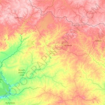
Name: Kalumbila District topographic map, elevation, terrain.
Location: Kalumbila District, North-Western Province, Zambia (-13.01392 24.81905 -11.71103 26.47478)
Average elevation: 4,304 ft
Minimum elevation: 3,556 ft
Maximum elevation: 5,236 ft
Other topographic maps
Click on a map to view its topography, its elevation and its terrain.
Mufumbwe
Zambia > North-Western Province
Mufumbwe, Mufumbwe District, North-Western Province, Zambia
Average elevation: 3,819 ft
Mufumbwe District
Zambia > North-Western Province
Mufumbwe District, North-Western Province, Zambia
Average elevation: 3,845 ft