
Okuru topographic map
Interactive map
Click on the map to display elevation.
About this map
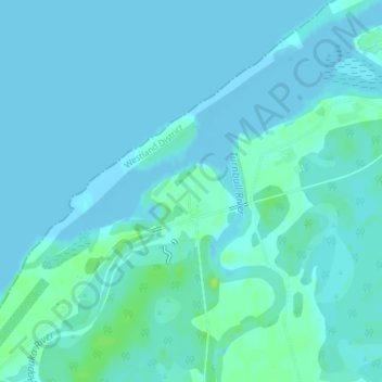
Name: Okuru topographic map, elevation, terrain.
Location: Okuru, Westland District, West Coast, New Zealand (-43.91675 168.89004 -43.89675 168.91004)
Average elevation: 10 ft
Minimum elevation: -7 ft
Maximum elevation: 43 ft
Other topographic maps
Click on a map to view its topography, its elevation and its terrain.
Gillespies Beach
New Zealand > West Coast > Westland District
Gillespies Beach, Westland District, West Coast, New Zealand
Average elevation: 46 ft
Hokitika
New Zealand > West Coast > Westland District
Hokitika, Westland District, West Coast, 7810, New Zealand
Average elevation: 46 ft
Waikowai Stream
New Zealand > West Coast > Westland District
Waikowai Stream, Westland District, West Coast, New Zealand
Average elevation: 43 ft
Hooker Glacier
New Zealand > West Coast > Westland District
Hooker Glacier, Westland District, West Coast, New Zealand
Average elevation: 6,332 ft
Belmont
New Zealand > West Coast > Westland District
Belmont, Westland District, West Coast, New Zealand
Average elevation: 5,325 ft
Haast
New Zealand > West Coast > Westland District
Haast, Westland District, West Coast, New Zealand
Average elevation: 49 ft
Fox Glacier
New Zealand > West Coast > Westland District
Fox Glacier, Westland District, West Coast, New Zealand
Average elevation: 6,063 ft
Franz Josef
New Zealand > West Coast > Westland District
Franz Josef, Westland District, West Coast, 7856, New Zealand
Average elevation: 909 ft
Mount Tasman
New Zealand > West Coast > Westland District
Mount Tasman, Westland District, West Coast, New Zealand
Average elevation: 9,180 ft