
Allerona topographic map
Interactive map
Click on the map to display elevation.
About this map
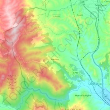
Name: Allerona topographic map, elevation, terrain.
Location: Allerona, Terni, Ombrie, 05011, Italie (42.76451 11.89203 42.86959 12.06507)
Average elevation: 1,257 ft
Minimum elevation: 449 ft
Maximum elevation: 2,671 ft
Other topographic maps
Click on a map to view its topography, its elevation and its terrain.
Monte Ventone
Italie > Ombrie > Terni > Amelia
Monte Ventone, Amelia, Terni, Ombrie, 05022, Italie
Average elevation: 1,880 ft
Ferentillo
Ferentillo, Terni, Ombrie, 05034, Italie
Average elevation: 2,195 ft