
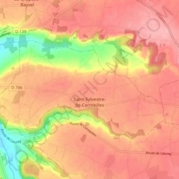
Saint-Sylvestre-de-Cormeilles topographic map
Interactive map
Click on the map to display elevation.
About this map
Name: Saint-Sylvestre-de-Cormeilles topographic map, elevation, terrain.
Average elevation: 479 ft
Minimum elevation: 233 ft
Maximum elevation: 597 ft
Other topographic maps
Click on a map to view its topography, its elevation and its terrain.
Vatteville
Vatteville, Les Andelys, Eure, Normandie, France métropolitaine, 27430, France
Average elevation: 371 ft
Champenard
Champenard, Les Andelys, Eure, Normandie, France métropolitaine, 27600, France
Average elevation: 427 ft
Les Planchettes
France > Normandie > Eure > Château-sur-Epte
Les Planchettes, Château-sur-Epte, Les Andelys, Eure, Normandie, France métropolitaine, 27420, France
Average elevation: 233 ft
Saint-Thurien
France > Normandie > Eure > Le Perrey
Saint-Thurien, Le Perrey, Bernay, Eure, Normandie, France métropolitaine, 27680, France
Average elevation: 364 ft
La Trinité
La Trinité, Évreux, Eure, Normandie, France métropolitaine, 27930, France
Average elevation: 430 ft
Saint-Marcel
Saint-Marcel, Les Andelys, Eure, Normandie, France métropolitaine, 27950, France
Average elevation: 253 ft
Le Bec-Hellouin
Le Bec-Hellouin, Bernay, Eure, Normandie, France métropolitaine, 27800, France
Average elevation: 335 ft
Conches-en-Ouche
Conches-en-Ouche, Évreux, Eure, Normandie, France métropolitaine, 27190, France
Average elevation: 495 ft